
Demo: Equatorial Coordinates Simulation
Background: The Equatorial System
Just as cartographers on Earth developed a coordinate system of latitudes and longitudes to map the geological and geographical features of the planet, astronomers have developed their own system called the Equatorial Coordinate System (ECS) to map and locate objects in the sky.
Similar to the way that the latitude-longitude system lays down a grid on the earth's sphere, the astronomical coordinates lay down a grid on an imaginary sphere projected outward from the earth's surface.
Terminology
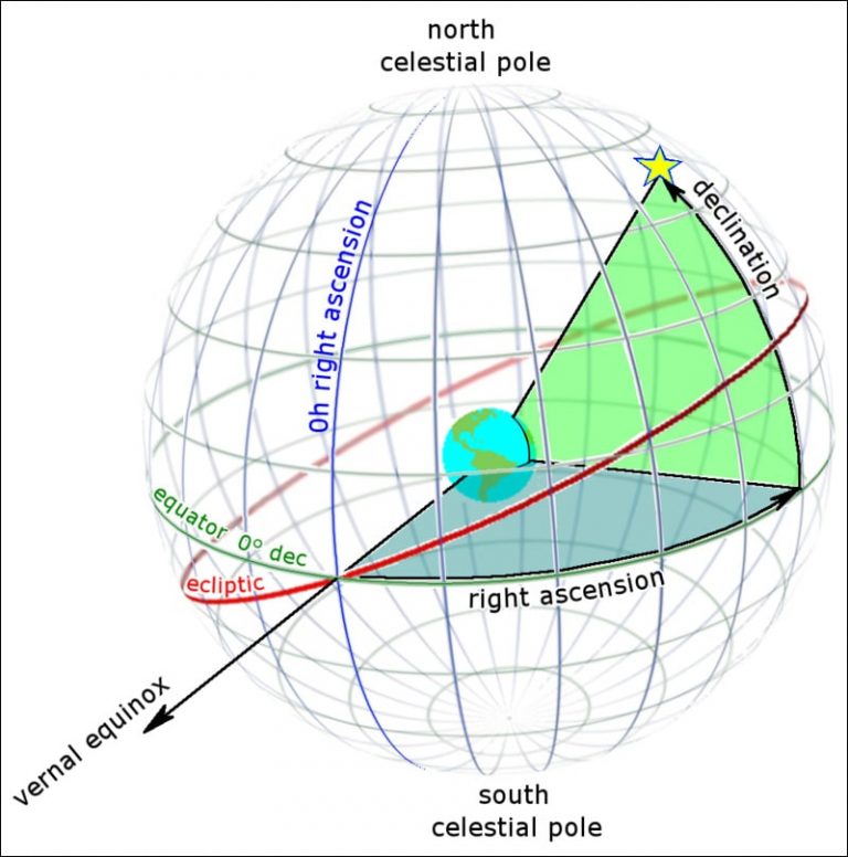
The North and South Celestial Poles line up with the earth's rotational axis, and the Celestial Equator lines up with the earth’s equator.
Another line is the Ecliptic, which represents the plane in which the earth revolves around the Sun.
The zenith is the point in the sky that is directly above the observer. This point will change as the observer changes latitudes on Earth.
The meridian is a line that bisects the North and South Celestial Poles and the observer’s zenith. In astronomy, we use the term ‘transit’ to describe when a star, planet, moon, etc. crosses the meridian. When a celestial object transits the meridian, it has reached the highest point in the sky for the day and then will begin to set.
Instead of using latitude and longitude for the celestial sphere, the vertical and horizontal lines are labeled as Right Ascension (RA) and Declination (Dec), respectively.
Units of the Celestial Sphere
Astronomers can use the Right Ascension and Declination to locate or track any object in the night sky, regardless of the observer’s position on Earth.
Declination is measured in degrees north or south of the celestial equator, with negative numbers indicating south.
Right Ascension, on the other hand, is measured in 'hours', ‘minutes', and ‘seconds’, with 24 hours representing one full revolution (360º). Thus, one hour of right ascension is equal to 15º. Remember that the direction of the Sun on the Vernal Equinox is equal to an RA of 00h 00m 00s.
As an example, the Orion Nebula can be found on the celestial sphere at:
RA: 05h 35m 17s
DEC: -05° 23' 28”
___________________________________________________________________________________
The Celestial Sphere

1.) Label the Celestial Equator, Earth’s Equator, the North and South Celestial Poles, the Ecliptic, the position of Polaris, and Earth’s Rotational Axis. Mark on the diagram where the summer solstice, winter solstice, vernal equinox, and the autumnal equinox occur.
2.) What angle is the ecliptic inclined with respect to the celestial equator?
3.) What celestial objects lay on or near the ecliptic? Name at least five and explain your answers.
___________________________________________________________________________________
The Celestial Sphere: Local Viewpoint

Assume the diagram provided is for Iowa City, IA, which is at a latitude of ~42 degrees.
1.) Identify the North Celestial Pole (NCP), Celestial Equator, zenith, the meridian, the horizon, and the cardinal directions along with their azimuth angle. Then draw where Polaris is and draw the path of a star over the course of one night.
Hint: The degree of elevation of Polaris is the same as our latitude. This was how, pre-GPS, people knew where they were in the world.
2.) What is the Sun’s elevation at noon on the Vernal Equinox? Mark it on the diagram. Hint: see the previous figure, and think about where the Sun is in relation to the Celestial Equator on this date.
3.) For Iowa City, what is the elevation of the Sun at noon on the Summer Solstice. Mark it on the diagram.
Image Credit:
[[Tfr000 (talk) 15:34, 15 June 2012 (UTC) - Own work, CC BY-SA 3.0, https://commons.wikimedia.org/w/index.php?curid=19907447]]